About Mexico

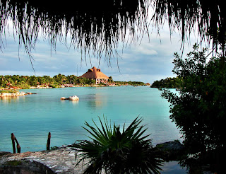


Mexico is a country in North America, lying between the United States of
America to the north, and Guatemala and Belize to the southeast. The Republic
of Mexico is vast, comprising nearly two million square miles of coastline,
desert, rain forest, mountains, and fertile plains. Its extensive coastlines
include the Gulf of Mexico and the Caribbean Sea to the east and the Pacific
Ocean to the west.There are two major peninsulas in Mexico that are almost
countries themselves. In the west is the poetically barren Baja Peninsula,
which seals in the biological riches of the Sea of Cortes. The two main
mountain ranges, the Sierra Madre Occidental and the Sierra Madre Oriental, hug
the west and east, finally merging into the volcanically active central highlands
and the capital, Mexico City the most populous city in the world.Mexico is
highly dependent on exports to the U.S., which represent more than a quarter of
the country's GDP (gross domestic product). The result is that the Mexican
economy is strongly linked to the U.S. business cycle.The population of the
area around Mexico City is nearly 20 million, which would make it the largest
concentration of population in the Western Hemisphere. About 76% of the people
live in urban areas. Cities bordering on the United States, such as Tijuana and
Ciudad Juarez and cities in the interior such as Guadalajara, Monterrey, and
Puebla have undergone sharp rises in population in recent years.Mexico has been
graced with an unusually temperate climate year round. Varies from desert like
regions on the northwest part of the country and temperate in the northeaster
part, but note that much of the northern Mexican territory gets rather cold
during the winter with average day time highs from 8 to 12C, overnight lows
average around -5C and snow is sometimes frequent in certain northern places
like the Sierra Madre of Chihuahua, Durango, Coahuila, Nuevo Leon, and northern
Tamaulipas but can also occur at higher altitudes in the temperate forests in
the central part of Mexico.Mexican summer is also the rainy season, although
the rain rarely lasts more than a few hours, and typically arrives in the late
afternoon. Extremes are present only in the North and in Baja, both of which
have deserts where the temperature leaps above 100F. Also, northern Mexico gets
very hot during the summer with sudden violent storms in the afternoon, with
heavy rain and hail, also an isolated tornado can occur with these storms but
rarely, and the temperatures during the day can quickly exceed 39C.In the Caribbean
Sea meets the Yucatan Peninsula, coral reefs come alive, with sea creatures,
great and small. The Pacific coast attracts elephant seals and spectacular grey
whales, which choose Mexico to breed and give birth, year after year. In the
Plaza de las Tres Culturas celebrate the three major cultures that have shaped
Mexico: there are Aztec ruins, the 17th-century colonial church of San Diego
and several late 20th-century buildings. Even the dead are alive here, at least
once a year; on the Day of the Dead, the living bring gifts to their dearly
departed and spend the night in their company, remembering and celebrating how
things used to be.Nor is the desert a barrier to life, it is home to agaves,
the mother of all tequilas. The blue plant has a lot to answer for in Acapulco
and Cancun, where everybody come ashore after a day in the surf to flirt in
bars and nightclubs.Mexico is the most populous Spanish speaking country in the
world and the second most populous country in Latin America after Portuguese speaking
Brazil. They say that Mexico is a country no one ever leaves. Mexico is ranked
7th major destination for foreigner visitors, according to WTO. Every year,
millions of tourists pass through, and Mexicans jovially warn that a part of
them will remain behind forever.The generosity of the Mexican people is
unsurpassed. The people are vivacious lovers of free time and socialising, and
work will never have the importance that friends and family do. Knowing a few
simple sentences in Spanish will win hearts. Its unique and traditional Mexican
food can often be very spicy, it recommend if you are not used to peppers,
always ask if your food includes it.Most visitors are vacationing North
Americans who wind up on the brilliant beaches of Cancun, Acapulco, Mazatlan,
and Puerto Vallarta. The beaches, of course, are among the world's best. And
the generosity of the Mexican people is unsurpassed. Knowing a few simple
sentences in Spanish will win hearts.
Tajín

El Tajín which means City of thunder, hurricane or lighting in Totanac language is located in what
nowadays is the municipality of Poza Rica in Veracruz, Mexico. Despite of not
being completely excavated, this amazing archaeological site has almost 150 buildings,
and just 20 of them have being restored.Consider also, one of many enigmatic
places, El Tajín is still under scientific studies which keep revealing more
unusual explanations for unusual buildings; discovering more and more mysteries
of the Totanacs culture whose god was called Tajín.This mysterious city had many uses,
including a commercial interchange city, as same as both a political and
spiritual center. According to the just excavated part, it has an extension of
1 kilometre square, and there is located many temple-pyramids, palaces and
courts.One of the most famous buildings in this site is the Pyramid
of the Niches which
60 feet high and 6 terraces which are well forming 365 niches painted blue on
the frames and red in the insides, so this suggest, like many other sites in
Mexico, to the Scientifics that these structures resemble calendars and time,
or some kind of measurement device. Besides, the Minor Plaza or Plaza Menor in
Spanish, there are around of 17 Ball Courts building where has been found human
sacrifices and it is believed that in some how they are related to the ball
games that Totonacs people used to play here, depicting ritualistic games.For
these reasons and many more, this place has become exciting due to the new
mysteries revealed in here, discovering unique and unusual buildings.
Xel Há Park

The natural site of Xel Há, or Xelhá written in Spanish, is a Maya term
which means spring (xel) and water (ha’) referring to the
place where the water rises. It is located on the Caribbean
coast, in the Mexican State of Quintana Roo, within the Riviera Maya, about 122
kilometres to the south of Cancún, 240 kilometres to the north of Chetumal, and
about 13 kilometres to the north of the Archaeological Site of Tulum, passing
through the Cancún-Tulum road.The turquoise lagoon of smooth running currents and
exuberant jungle is the wonderful place close to the sea. This aquatic paradise
unique in the world houses more than 300 different species of Flora and Fauna,
which are able to see either by walking, little trains, or bicycles.The cove is
a natural aquarium where inhabit hundreds of marine species, several tropical
fishes, and plentiful flora. Among their typical fauna founded in Xel Há, it is
very recognizable 100 species of birds and 350 species of plants.There is a
place, located in the north of the park, where is able to swim
with dolphins. As same as, The Turtles
Reserve, that from April to November annually comes to nest
around 20,000 baby turtles which are set free; it is also under Research in
order to learn more about marine life finding out the ways to contribute with
the ecological maintenance of this gorgeous area. Here is also able to see
those 3 manatees that found refuge in this natural
sanctuary.Across the entrance of the lagoon there is a shark barrier allowing
the public to swim and snorkel in the lagoon. The limestone underwater has been
eroded into multitudinous small caves and innumerous grottos. Some of the
principal activities offered by the park are snorkelling, scuba diving,
dolphins swimming, etc. but, there are also overland activities to enjoy with
the family, like the excursion of the Sendero de la Conciencia which talks about how to take care the
environment; to cross over the Laminate Bridge with 80m of height to enjoy of a
marvellous view of the nature; the Reforestation Area into the jungle called Chacahs’ Garden where many celebrities have
collaborated planting a tree; and many more.
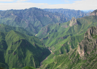
Copper Canyon

The
Copper Canyon, in Spanish Barranca
del Cobre, is located all over the Sierra Madre Occidental Range in the
state of Chihuahua, Mexico; nowadays, they are in what is north-western Mexico.
It is one of the youngest geological formations, and casually, they are also
the largest in the North American
continent, alike the Grand Canyon of United States.The landscape is a
formation of many rivers, which born in the highest pine forests at 10,000
miles with gorgeous step-walled deep narrow valley s into the volcanic rocks of
Sierra Madre Mountain Range, over 5,000 feet with giant cactus and tropical
trees.Due to the many watered thunder storms, the canyon country is always the
perfect combination of colours, among greens, reds and yellows; mixed with the
dense oaks in spring, and during autumn filled with wildflowers.The trips to the canyon are on board of the historic Chihuahua
al Pacífico Railroad; also know as Chepe,
which was originally designed to connect the Pacific Ocean with the central
Mexican desert territory and Chihuahua. Built in almost 90 years, it always has
had an international vision and until now it is an engineering masterpiece.
Nowadays, the train starts its way from the Pacific Ocean up into the
splendorous Copper Canyon, crossing 39 bridges and 86 tunnels.Besides, the Chepe makes possible the entry for tourists
to the Copper Canyon passing through the area long inhabited by the Tarahumara
Indians, who are small and shy natives, famous for their running ability. There
is also some 50,000 Raramuri who lives in caves and other primitive
dwellings.
Uxmal

The Archaeological site of Uxmal, Óoxmáal in Yucatec Maya, is located 78
kilometres south of Mérida, Yucatán; and 15 kilometres southeast of the town of
Muna; at 78 feet above sea level; and travelling by car it is about 1.5 hours
from Mérida.Despite of the continuous studying of the archaeological site to
consolidate and restore the buildings, this popular tourist destination has not
specific dates of occupation and population. However, the estimates of its
foundation are about 700A.D. getting to have 25,000 inhabitants; and its period
of construction is between 700 and 1100A.D. where in most of the building are
unveiled symbolic motifs and sculptures of its god
Chaac, the god of the rain.When the process of restoration
finished, Uxmal was in better condition than many other Maya sites. This fact
was possible thanks to its well and unusual construction by the Xiu, using well
cut stones and setting them into a core of concrete.Uxmul is characterized by
the Maya architecture, where is seen the elegance and beauty of the buildings
very similar to and compare with Palenque. In both
archaeological sites predominates the Pucc style of Maya. Thanks to this good state of
preservation it is possible for the tourists to have a better idea of how the
entire center was in ancient times.Some remarkable buildings include The
Governor's Palace atop
a huge platform with longest facades; the fine and unusual Pyramid
of the Magician, which layers are oval and placed over older
ones, a very typical way of construction; The Nunnery Quadrangle,
called by the Spaniards built with several fine quadrangles and carved facades
both on the inside and outside faces; The Ballcourt, the
traditional building for playing ballgame made in 901A.D. by the ruler Chan
Chak K'ak'nal Ajaw.There are also many more buildings, varying in size and
preservation, which add a mysterious significance to Uxmal; such as
quadrangles, monuments, and temple-pyramids called like House of the Turtles,
South Temple, House of the Birds, North Long Building, House of the Doves, and
Grand Pyramid.Uxmal writing, like many Maya cultures, was the hieroglyphic
inscriptions. They were also found in group on a stone stele; picturing older
rulers of Uxmal and showing signs of have been broken and repaired; possibly
caused by some war or battle.
Monte Albán

Monte Albán is one of the biggest pre-Columbian
archaeological sites in the south of the State of Oaxaca, Mexico. Its location
is over some low mountains that are rising above the Valley of Oaxaca, between
Tlacolula, Etla, and Zimatlán/Ocotlán valleys. Currently, it is locate about 9
kilometres west of now is Oaxaca City.The ceremonial center of Monte Albán is
situated on the top of a lonely mountain, in the middle of the Central Valleys
of Oaxaca. Apparently, the strategic
location, where the political, religious and army elite
resided, might allow a better defence of the city in case there would be army
attacks; but the population was located on the mountainsides.As same as many
other Mesoamerican metropolis, this Archaeological site was one of those cities
with a multiethnic population.
During its development, the city kept strong relationships with some other
important cultures in Mesoamerica, specially the Teotihuacán Culture. Despite
the city was abandoned for the elite and part of its population, Monte Albán
was reutilized by the Mixtec during the post-classic period.The
archaeological site is not mentioned in the Spaniards chronicles, so it is very
probable that its existence was known until the Colonial Period, beginning the
19th century. It was in the middle of the 20th century that the Mexican Alfonso
Caso discovered the Tumba 7, where was the
biggest Mesoamerican deposit of gold work ever found until now.The Valley of
Oaxaca is characterized by a warm climate with moderated rains; however, it is
the Atoyac River which guarantees the water source for the agriculture,
which in Monte Albán times was the principal economic activity. However, the
mountain morphology of Monte Albán was adapted in order to satisfy the city
constructions and its population; for example, the Main
Plaza turned to
be a flatten platform over were constructed the buildings of the city; as same
as the mountainsides, where the inhabitants constructed their homes with little
water reservoirs, necessary for the agriculture during the drought
days.Nowadays, the Archaeological site Monte Albán is open to the public every
single day from 8:00am to 5:00pm. In the site it is possible to visit almost
all the restored buildings.
Mexico Downtown

The Historical Center of Mexico, known also as El
Centro or Downtown
Mexico, currently includes about 1,436 historically important
buildings constructed between the 16th and 20th centuries and they are extended
over 9 square kilometres and 668 blocks. It is divided in two zones, in order
to preserve them, which are the Zone
A that
comprehends the pre-Hispanic, Viceroy and Independence periods and the Zone
B that
comprehends the 19th century period.Predominantly, its historical relevance
over many periods, El Centro owns many public plazas, buildings, palaces,
temples, museums and markets; all of them points of reference survivors of the
time and catalogued with artistic and historical values. El Centro and its old
part of the town also receive the name of La Casa de los Palacios,
The House of the Palaces.Besides, whole this area is focused on the Main Plaza,
known as Zócalo, which is the
largest plaza in Latin America and the second largest in the world, and being
able to hold up around 100,000 people.
Palenque

Palenque is located in the Mexican State of Chiapas,
really near to the Usumacinta River. Although Palenque is smaller than many
other Maya sites, its fine architecture, roof comb, sculpture and bas-relief
attracts more tourists. Consider as one of the most captivating places of
Mexico, the ancient city is full of mysterious; in addition its stone temples
looking out over the jungle surrounded by mountains give Palenque that
unforgettable experience for travellers.Some of the most important structures of
Palenque are The Palace, which has
a wild artificial terrace and is able to connect many adjacent buildings; The
Temple of the Inscriptions, in which is recorded approximately
180 years of the city’s history; The Temple of the Cross group, Temple
of the Sun and Temple of the Foliated Cross,
which are graceful temples that illustrate two figures that are a
representation of ritual objects and simulate to a central icon; and many
more.The way of transportation to Palenque would be sometimes difficult, but once
the travellers are there, the enthusiasm of the viewing is well worth. Also,
there is the opportunity to rent a car for the most adventurous, driving from
San Cristobal to Palenque for five hours, however, do not neglect be aware for
potholes and obstructions, as same as, do not forget to keep your passport and
travel documents with you for the military roadblocks.
Teotihuacan
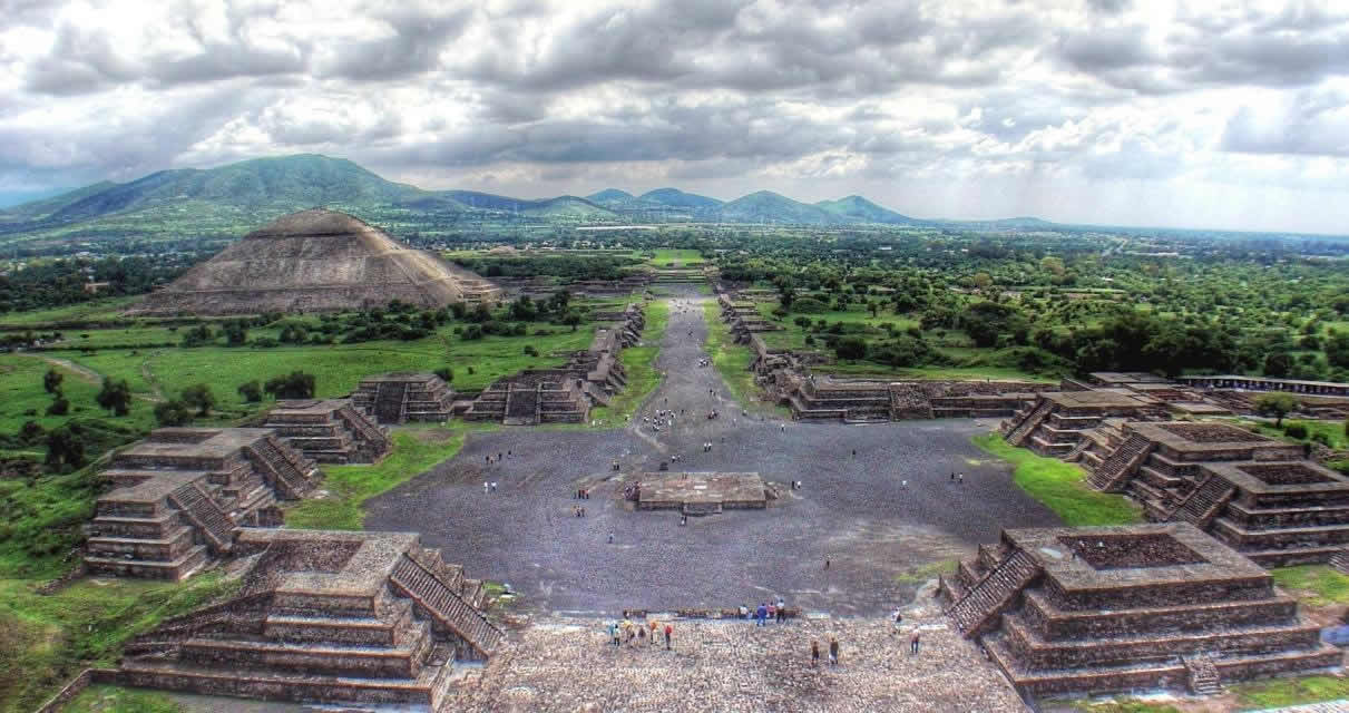
Teotihuacan is the most visited archeological complex
of Mexico. It is located around 30 miles (48 Km) northeast Mexico City in the
municipality of San Juan de Teotihuacan. Within this archeological complex are
some of the largest pyramidal structures of America. The original name of the
city was lost in the time as well as the name of the civilization that
constructed the city. The current name “Teotihuacan” was given by the Aztecs
and it has several interpretations, being the most accepted "place of the gods"
or "place where one becomes a god".The city is composed by many
structures; burn there are five main elements: the Avenue of the Dead, the
Pyramid of the Sun, the Pyramid of the Moon, the Ciudadela and the Feathered
Serpent Pyramid.The Avenue of the Dead is the main avenue of the city; it leads
from the Moon Square to the Ciudadela, from north to south for more than 2.5
Km, dividing the city into two zones. The avenue is flanked by wonderful
ceremonial buildings such as the Pyramid of Sun and Pyramid of Moon.The
Ciudadela (Citadel, named thus by Spanish who believed that it was a fort) is a
great square (about 160 000 square meters) surrounded by several temples. It
believes, that the Ciudadela was the religious and political center of
Teotihuacan. The Ciudadela contains the Feathered Serpent Pyramid, a stepped
pyramid which is one of the most impressive structures of the complex. It is
dedicated to the Feathered Serpent or Quetzalcoatl one of the most important
gods of the Mesoamerican culture.The largest and most impressive structure of
the Teotihuacan complex is definitely the great Pyramid of the Sun. This great
structure has a base of 215 by 215 meters and it is 63 meters height. It is at
the east of the Avenue of Dead in the northern part of Teotihuacan. It was
originally composed by four stepped platforms a terraced platform and a
superimposed temple; unfortunately the upper-most portion of the structure was
totally destroyed. The excavation and reconstruction of this monument began at
the beginning of the XX century by Leopoldo BatresThe Pyramid of the Moon is a
beautiful building smaller than the Pyramid of the sun, located at the northern
extreme of the Avenue of the dead. This Pyramid dates from 200 AD. This pyramid
has a platform at top, which was used to do ceremonies in honor to
Chalchiutlicue, goddess of the water and the moon.
Cacahuamilpa Caves

The Cacahuamilpa Caves National Park or Grutas
de Cacahuamilpa as
is named in Spanish; comes from the etymologic Cacahuamilpa word of the Náhuatl
language, which means peanuts sowing. It is
situated inside of the physiographic province of Sierra Madre South, in the
north zone of Guerrero State, Mexico.Also, it can be situated 52 kilometres
from Taxco city, and 220 kilometres from Acapulco port; very close to the
states of Igual and Morelos at 66 kilometres and 81 kilometres, respectively.
By car, there are also two ways to get there, the Cuernavaca-Grutas and the
Toluca-Taxco roads.Cacahuamilpa caves are considered one of the most amazing
caves in the World, cover 1,600 hectares and 1,380 metres long holding inside
endless strange figures such as faces, facial expressions, animals, places,
etc. which are cause of admiration and wonder among the visitants, particularly
of those scientists who are dedicated to the Speleology. The caves
are distributed in 80 both artificially and naturally full illuminated rooms,
at least; also, their heights ranged between 30 metres to 70 metres.The
formations of these natural caves belong to the ancient traces of the sea made
by the sediments that the water dragged. This is the principal reason why these
rocks are so soluble allowing the pass of water, and through its route creates
fissures at the beginning, to form later subterranean rivers in which bed
deviation form the caves.At this location there is a warm semi-dry climate;
however, during the rains the forest becomes lush, while during the dry season
the landscape turns a wood with no leafs. The low latitude-rainforest
vegetation include many trees such as Bursera bipinnata, Bursera copallifera
and Bursera jorullensis; as same as Crescentia Cujete and Crescentia Alata,
used in the cooking utensils production.Furthermore, among some of the
distinguished animals, there are the cacomistles, badgers, racoons,
rattlesnakes, iguanas and green iguanas, new world vultures, pumas, small
tigers, rabbits, armadillos, otters, golden eagles, lynxes, etc. The National
Park has also Limestone Mountains passed by subterranean rivers of San Jerónimo
and Chontalcoatlán, both converging in the Amacuzac River, which flows into the
Pacific Ocean.This spectacular natural formation are open to the public with
daily visits starting at 10 am, the tour is 2 hours walking along 2 kilometres.
Chichen Itza

The famous Mayan pyramids of Chichen Itza (chee-chehn
eet-sah) in Maya literally means: "Mouth of the well of the Itza",
the name Chichen Itza is a Mayan word: CHI (mouth), CHEN (well) and ITZA (of
the Itza tribe), it is located a 75 miles east of Merida, the Capital of the
State of Yucatan, Mexico. This archaeological site is rated among the most
important of the Maya culture and covers an area of approximately six square
miles.The architectural characteristics of Chichen Itza and that have a direct
relationship with the Mayan Toltec style are: "El juego de la
Pelota", "El Castillo", "El Grupo de las Mil
Columnas", "El tzompantli", El Edificio de las Aguilas",
"El templo de los Guerrerros", and "El Mercado". All of
these buildings have the same decoration motives found in Tula. The most
frequent representations are warriors and Quetzalcoatl.The main attraction is
the central pyramid, a square-based, stepped pyramid that is approximately 75
feet tall, El Castillo de la Serpiente Emplumada, which means "Castle of
the Plumed Serpent," and is pictured at the top. The plumed serpent is a
popular deity in various Mesoamerican cultures. "El Castillo" is
surely the place where the ceremony of the descent of Kukulkan was held. The
pyramid has special astronomical layout so that a game of light and shadow is
formed. On March 21st the body of the serpent metaphorically descends from the
temple on top of the pyramid and arrives at the heads at the foot of the
staircase.Just beyond El Castillo you will find a large ball court where Mayan
men played a game called pok ta pok. Anthropologists believe that the object of
the game was to hurl a ball through a ring that was mounted on a wall, seven
meters above the ground. The largest Ball Game in Mesoamerica is 168 meters in length
and 70 meters in width.The Temple of Chac Mool, upon whose walls and interior
pillars there are richly colored carvings of plumed serpents, warriors, and
priests. The upper building only partially reflects its true grandeur. There
are three sculpted masks with extremely long noses on the outer walls and at
the corners. On the inner walls of the vaults there were murals with scenes of
war and daily life. The altar tables and benches may have served as seats and
thrones for dignitaries.In the "Templo de los Guerreros" there is a
temple on the top part where the entrance columns are typically Toltec. Another
one of the buildings that have a Toltec seal without is the "Muro de los
Craneos". These buildings were destined to be the mausoleums of the tying
up the years. Every 52 years the ancient Mayans and other cultures would tie up
a sheaf of years to end a cycle. Temple of the Carved Panels, the name of this
building comes from the relieves carved on the north and south walls of the
colonnade, depicting scenes of numerous people, plants, and animals, both real
and imaginary, which are dominated by two warriors. The building is made up of
a temple erected on a slab foundation with a colonnade in front of it. The
offerings discovered during exploration of the fire - related rituals.All areas
can be seen comfortably in one day. Also you should enjoy the wonderful Light
and Sound Show that is held every evening. At the entrance to Chichen Itza,
there is an informative museum, a dining room, clean restrooms, a few gift
shops and vendor stands.
Calakmul

The Archaeological site of Calakmul is located very
deeply in the jungles of Petén Basin, over 1,800,000 acre of the Calakmul
Biosphere Reserve in
the State of Campeche, Mexico; into the limits of the municipalities of
Champotón and Hopelchén; and 30 kilometres from the Guatemalan border.This
preponderant Maya site was the major urban center of the Classic Period, with
more than 500 archaeological pieces, so that, it is consider the biggest valuable texts deposit of
dynastic Maya because
of there are many steles surrounding the Main Plaza.Over 6,750
ancient Calakmul structures, the largest one is the Great
Pyramid of 55 metres high and 4 tombs inside, being the tallest
Pyramid of the whole Maya Pyramids, and as many other similar
constructions, to reach its current size, 2 square kilometres, it was increased
by building upon other existing temples; and the whole site covered with
residential structures is about 20 square kilometres.Being also the biggest
Maya City of Mexico, next to Palenque in Mexico and Tikal in Guatemala, Calakmul was part of this powerful triangle. It
is also one of the richest places in structures including 117
steles, the largest number in Mexico, which represent its rules
and their wives. However, due to they are sculpted in soft limestone, most of
them have eroded making harder, and in some cases, impossible to interpret
them.There were also discovered many detailed murals in Calakmul, which in the
opposite of other cultures, these murals do not represent the elite activities,
in the other hand, the scenes detailed are from the people during the food
preparation and eating like maize drink, tamales, etc. The murals also have
glyphs describing daily events, and the most prominent is a lady, nowadays
known as Señora Piedra 9. Among
other important materials, there are many pieces of ceramic, which allows to
the anthropologists to identify and know better the thoughts of the people who
lived in the archaeological site.Calakmul represent the ecological line of
Yucatan Peninsula, located in the middle of tropical forests with a warm and
sub-humid climate and rains during the summer, while during the winter the
temperature descend sometimes until 32ºF. This combination has allowed the
creation of rich fauna, including jaguars, turkey vultures, xoco-pheasant,
toucan, three types of eagles, tapirs, peraries, anteaters, armadillos,
parrots, 400 species of butterflies, 147 types of vertebrates, and rich flora
with the famous orchids, and about 1600 varieties of plants.This amazing
Archaeological Site is open to the public during the whole week, from 8am to
5pm.
Parícutin Volcano

Parícutin is a cinder cone volcano in the Mexican
state of Michoacán, close to a lava-covered village of the same name. It is
part of the Michoacán-Guanajuato Volcanic Field which covers much of west
central Mexico.Dioniso Pulido, a Tarascan farmer, along with his wife and their
son witnessed the initial eruption of ash and stones first-hand as they plowed
the field, that began as a fissure in his cornfield. Much of the volcano's
growth occurred during its first year, while it was still in the explosive pyroclastic
phase. Nearby villages Paricutín (after which the volcano was named) and San
Juan Parangaricutiro were both buried in lava and ash; the residents relocated
to vacant land nearby.After one year, the volcano had grown 336 meters tall,
for the next eight years it would continue erupting, but the activity would
slowly decline. In 1952 the eruption ended and Parícutin went quiet, attaining
a final height of 424 meters above the cornfield from which it was born. Like
most cinder cones, it is a monogenetic volcano which means that it will never
erupt again.Parícutin is the youngest of more than 1400 volcanic vents in the
Trans-Mexican Volcanic Belt and North America. Three people died as a result of
lighting strikes caused by the eruptions, but no deaths were attributed to the
lava or asphyxiation.During the active phase of Parícutin volcano, shots were
included in the film Captain from Castile by the 20th Century Fox’s, released
in 1947.Actually two different elevation are attributed to Paricutín: 3170 meters
by the Smithsonian Global Volcanism Program and SummitPost.org and 2774 meters
by Peakbagger.com and Bartleby.com along with GPS measurements on Google
Earth.The most recent volcano formed on the Western Hemisphere, from its birth
of the eruption between 1943 and 1952, it has represented a dramatic period in
the lives of Parícutin people, who losing crops, livestock and suffered
substantial property damage during the natural disaster.
Tulum

Tulum, which is written as Tulu'um in Modern Maya and translated as wall or fortification, was the
principal port and walled city for Cobá, the large ruined city of the Pre-Columbian
Maya civilization. Located in the state of Quintana Roo, Mexico,
it is on 39 feet cliffs extended all over the east coast of the Yucatán
Peninsula on the Caribbean Sea and nowadays it is consider one of the
best-preserved coastal Maya sites being really popular site for tourists.The
architecture of Tulum is really typical to most of the Maya sites on the east
coast, which is recognized by a step surrounding the base of the building and
sitting on a low substructure. Inside the rooms, there are usually one or two
small windows with an altar at the back wall. Generally, the doorways are
narrow with columns used as support when the building is big enough, with two
sets of molding near the top walls. According to this type of architecture,
Tulum is compare with the Chichen Itza architecture but in smaller
scale.Due to Tulum was a walled city, it needed to be
protected, therefore on the landward side there is a big wall averaged about
4-5 metres long and on the other side by the steep sea cliffs, furthermore,
this wall is big enough around 8 metres thick and 400 metres long. In order to
improve their defense, there are small structures that are watch towers located
on the southwest and northwest corners. Also, the wall enclosing the site was
slightly shorter, about 170 metres on both sides; and around there are five
gateways, with two on each the north and south side, and one on the west. And,
according to the studies near the northern side there is a cenote,
a type of sinkhole, which would have provided the city with fresh water. Hence,
all this construction has taken a huge amount of energy and time which explains
how important was the defense to Mayan people and converting this site in one
of the most fortified sites. Likewise, there is a kind of landing beach
that would be useful for trading canoes, making of this site a peculiar trading
port and the reason why Maya founded Tulum here. Besides, here in Tulum, both
coastal and land routes converge showing contacts between areas all over
Central Mexico and Central America, and as a proof, there are copper artefacts,
ceramics, incense burners, gold objects, as same as salt and textiles were
found in Tulum that would be transported by sea to rivers through the Río
Motagua to Guatemala, and the Río Usumacincta/Pasión to the Gulf of
Mexico.Tulum, as an archaeological site relatively compact comparing with other
sites of Maya, is one of the best-preserved Maya sites becoming the third most
visited and a popular destination for tourists in Mexico with daily tour buses.
It is a very popular archaeological site because is near to the most popular
beach resort, Cancun, and its pictorial view of the Caribbean coastline.
Xochialco

The Archaeological Site of Xochicalco is located in
the municipalities of Temixco and Miacatlán in the Mexican State of Morelos, 38
kilometres southwest of Cuernavaca and 76miles from Mexico City. Asides of its
affinities with both the Maya area and the Toluca Valley, nowadays there are
still some residents of the Cuentepec Village that speak Nahuátl.Apparently and
according to the architecture of the site, it is speculated that the settlers
of Xochicalco might be artists from other parts of Middle America. Specially,
there are some interesting carved reliefs on the sides of the buildings, as the Temple
of the Quetzalcoatl, which shows the Teotihuacán and Maya
influences.The center of the ceremonial area is on a levelled hill; it is
surrounded by residential and most unexcavated structures which cover the
slopes of long terraces. There is also the Central Plaza as the most important civic and
religious space of Xochicalco; the Malinche or Ballgame court surrounded by twenty round altars and
one square altar used as the ritual calendar of 260 days; the Main
Plaza used as a
ceremonial and political space with a complete restriction of passing because
it houses the most important structures of the site such as the Temple of the
Feathered Serpent, Temple of the Steles, and the Houses of the principal kings
of the Xochicalco.There is also an Observatory, an
astronomical site, a cave in where the habitants of Xochicalco were dedicated
to study the Sun’s movement. Here, during 105 days, from April 30 to August 15,
the sun falls into the place through the mouth of the chimney. But, from May 14
to July 29 during the movement of the sun through the Tropic of Cancer, it is
at its zenith and astronomical noon creating its image on the floor of the
cave; for these reasons, the scientific studies demonstrated that this place
was also used for religious ceremonies. Besides, here is also attractive to see
how the solar energy acts as X-Ray when a hand is located under the
light, which effect allows seeing the flesh and bones of the fingers.The
archaeological site of Xochicalco is open to the tourists all week from 10am to
5pm, but the access to the Observatory is only allowed after noon. There are
two ways to go to Xochicalco; one is coming from Cuernavaca through the federal
road number 95 until Alpuyeca small town, once there the visitors must follow
the deviation road to Macatlan, 8 kilometres to the right; and the second way
is following the Sol road Cuernavaca-Acapulco until the Apuyeca Hut, from here
the visitors must follow the road described in the first way.
Tenochtitlán

Tenochtitlán, the ancient capital of the Aztec Empire,
is also known as Temixtitán or Temistitlán. As a powerful city, it had
to conquer the surrounding altepetls or Water Mountains with about 500,000
settle man during its peak until 1521, when the Spanish conquers, commanded by
Hernán Cortés, got to subjugate it.The city was found as a part of Lacustrine
System of the Mexican Basin, into an artificially made islet in the Texcoco
Lake with hydraulic work and artificial lands called chinampas,
gardens in rectangular plots divided by canals. Basically, Tenochtitlán was
ruled by a tlatoani, who was a
post held for life and its social structure was classified by social classes;
the nobles were the most privileged including the army people, traders and priests;
while the low class were the artisans, low-range army, common people, carriers
and slaves.During its peak, Tenochtitlán covered about 13 square kilometres at
the west of the shallow Lake Texcoco. By the time when the Spanish arrived,
they comprised Tenochtitlán and Tlatelolco in what is now Mexico City; but
initially, Tenochtitlán was connected by causeways leading north, south and
west of the city, and interlaced by canals used either on foot or via canoe.The Dike
of Nezahualcoyotl, the most important building, was constructed
by the ruler Moctezuma I and designed by Nezahualcoyotl himself. This piece of
engineering is estimated in between 12 and 16 kilometres of length, used to
keep the spring fresh water in the waters around the city.Through two double
aqueducts of about 4kilometres long each, the city of Chapultepec was provided
with fresh water used mainly for cleaning and washing, because most of the
populations liked to take a bath twice a day, using the root
of copalxocotl as
soap and the root of
maguey as washing
soap; furthermore, high-class and pregnant woman delighted to take a bath in
temazcalli, or sauna bath, which is
still used in some Mesoamerican cultures. Besides, for drinking, the city
populations preferred the water from the mountain springs.Geographically,
Tenochtitlán was divided in four zones, each divided on 20
districts or calpullis, and each was intersected by streets.
The most important streets were three; which according to Bernal Díaz del
Castillo, were wide enough for ten horses. Furthermore, the calpullis had a
specialty in arts and crafts, being able to compete with some other calpullis;
the calpullis were separated by transportation channels and wood bridges which,
every night, were removed for security.Additionally, each district had an own
tiyanquiztli or marketplace, and also a principal market in Tlatelolco, of
which when Cortéz saw it, he described as a twice of size building of the city
of Sevilla in Spain, with almost 60,000 people trading and buying daily.Tenochtitlán
had about 15 public schools, buildings and temples; and the most important into
a walled square, the Ceremonial Center. It included also the Main Temple, the
Temple of Quetzalcoatl, the Ball Game Court, the Rack of Skulls or Tzompantli,
The Temple of the Sun, The Gladiatorial Sacrifice Platforms, and minor temples.
In the outside, there were the Palace of Moctezuma with 100 rooms with its own
bath, constructed for ambassadors and lords of either conquered people or
allies. In conclusion, the city was distributed in a fabulous symmetry approved
by the city planner.Despite of the destruction of the Spanish conquer Cortés
all over the city, nowadays is able to see some of the ruins founded in the
1970’s during the construction of the Mexican metro-line. This construction was
part of the Main Temple or Templo Mayor.On
October 12, 1987 the construction of the Museum of the Main Temple was inaugurated and opened to the
public, just three blocks from the Zócalo o Plaza de la Constitución. Here, the
ruins are visible walking through the runways surrounding the archaeological
complex; however, some parts are covered from the sun in order to protect the
mural paintings over some walls.The way to visit the museum is taking the Line
2 in the Mexican Metro Line at the station, and it is open to the public from
Tuesday to Saturday from 9am to 5pm for tourists; and Sundays is open with free
entrance for Mexican people and residents.
Chapultepec Castle

The Chapultepec Castle, or Castillo
de Chapultepec in
Spanish, rises on the top of the Chapultepec Hill, where Chapultepec means the Grasshopper’s Hill in Náhuatl language. It is located in
Mexico City, D.F. at a height of 2,325 metres above sea level and used for
different purposes from Military Academy, Presidential House, Imperial
Residence, and Observatory to currently, a Museum.This magnificent and
historical construction includes structures built against the slope of the hill
itself, as same as walkways, gardens, exterior staircases integrated into the
topography; all of them spread over 10,000 square metres.The Castle access
starts off at the foot of the hill, through a ramp that leads all the way up to
the exterior gates. Most of its open areas, used in the past as military
manoeuvres, are composed by many courtyards and gardens. Here, is also found
the Citadel, where emerges the tower of the Tall Knight.Furthermore, the
insides of the Chapultepec Castle are luxury decorated by noteworthy paintings
on the walls, and more outstanding in the foyers and halls eulogizing the wide
and open areas that are symbol of the 19th and early 20th century buildings.
Hola! Los quiero invitar a conocer el directorio de Mens clubs de Merida donde se tiene agregado los mejores table dance del lugar para pasar un rato increiblemente agradable
ReplyDelete